Latest CFHC News
- See More News...
The Next Name on the List is Sara
Posted: 12:57 AM 12 November 2024 | 1 Comment | Add Comment | Newest: 02:27 PM 12-Nov EDT
4:00PM EDT 13 November 2024 Update
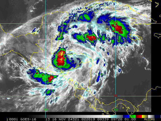
Advisories have begun on Potential Tropical Cyclone Nineteen (99L) in the Caribbean. Over the next several days the incipient cyclone is forecast to track west into Central America, where watches and warnings are now in effect.
2:00PM EDT 12 November 2024 Update
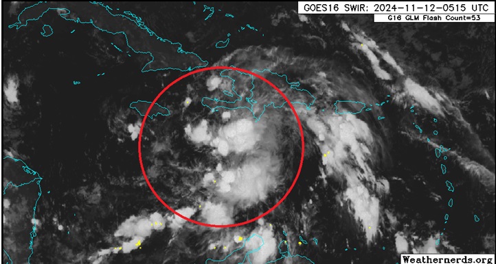
The Area of Interest we are tracking in the Caribbean has been Invest tagged, 99L, and recon missions are being tasked. Development odds are very high, with most modeling also suggesting that if the forecast TC doesn't run into central America, or at least not too quickly, Rapid Intensification is also likely.
Interests in the central to western and northwestern Caribbean may want to begin paying close attention as Watches and Warnings may be issued at any time this week.
Ciel
Original Update

Development in the Caribbean is becoming likely this week from a tropical wave interacting with a broad area of low pressure in the region and models are exceptionally bullish on this Invest TBD's prospects for the time of year. Shear is forecast to be unseasonable low and SSTs unseasonably warm.
The next name on the list in the 2024 Atlantic Hurricane Season is Sara.
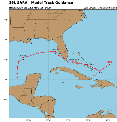
One might have to look back as far as 1985's Kate for a possible analog to current modeling and this system may take many by surprise if it does form and track towards the southeast US. Kate became the latest mainland US-landfalling hurricane on record.
We already have a Forecast Lounge up to go deeper into this system's modeling.
An Invest number will likely be assigned very soon and relevant links will be added.
Advisories have begun on Potential Tropical Cyclone Nineteen (99L) in the Caribbean. Over the next several days the incipient cyclone is forecast to track west into Central America, where watches and warnings are now in effect.
2:00PM EDT 12 November 2024 Update
The Area of Interest we are tracking in the Caribbean has been Invest tagged, 99L, and recon missions are being tasked. Development odds are very high, with most modeling also suggesting that if the forecast TC doesn't run into central America, or at least not too quickly, Rapid Intensification is also likely.
Interests in the central to western and northwestern Caribbean may want to begin paying close attention as Watches and Warnings may be issued at any time this week.
Ciel
Original Update

Development in the Caribbean is becoming likely this week from a tropical wave interacting with a broad area of low pressure in the region and models are exceptionally bullish on this Invest TBD's prospects for the time of year. Shear is forecast to be unseasonable low and SSTs unseasonably warm.
The next name on the list in the 2024 Atlantic Hurricane Season is Sara.
One might have to look back as far as 1985's Kate for a possible analog to current modeling and this system may take many by surprise if it does form and track towards the southeast US. Kate became the latest mainland US-landfalling hurricane on record.
We already have a Forecast Lounge up to go deeper into this system's modeling.
An Invest number will likely be assigned very soon and relevant links will be added.
Sara Event Related Links
Tropical Tidbits Page on system
[https://flhurricane.com/floatanimator.php?year=2024&storm=19 Flhurricane Satellite Floater Animation of Sara
GOES Floater
Tomer Berg Info page for Sara
Clark Evans Track Model Plot of Sara
(Animated!) Model Plots in Google Earth - In Google Maps
Clark Evans Intensity Model Plot of Sara (Animated!)
Clark Evans Track Plot of Sara
Clark Evans Top 10 Analog Storms for Sara
More model runs on from RAL/Jonathan Vigh's page
NRL Info on Sara -- RAMMB Info
COD Atlantic Satellite View
Latest X/Twitter posts from Flhurricane Twitter Page
Tweets by cfhc


