The Next Name on the List is Sara
Posted: 12:57 AM 12 November 2024 | 1 Comment | Add Comment | Newest: 02:27 PM 12-Nov EDT
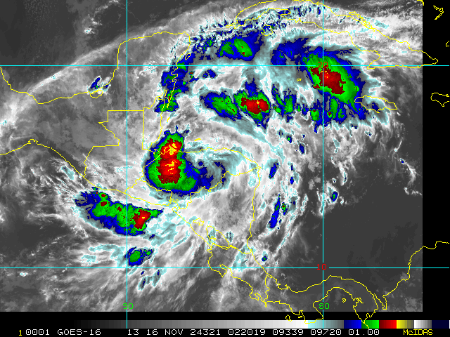
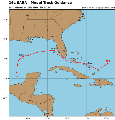
Advisories have begun on Potential Tropical Cyclone Nineteen (99L) in the Caribbean. Over the next several days the incipient cyclone is forecast to track west into Central America, where watches and warnings are now in effect.
2:00PM EDT 12 November 2024 Update
The Area of Interest we are tracking in the Caribbean has been Invest tagged, 99L, and recon missions are being tasked. Development odds are very high, with most modeling also suggesting that if the forecast TC doesn't run into central America, or at least not too quickly, Rapid Intensification is also likely.
Interests in the central to western and northwestern Caribbean may want to begin paying close attention as Watches and Warnings may be issued at any time this week.
Ciel
Original Update
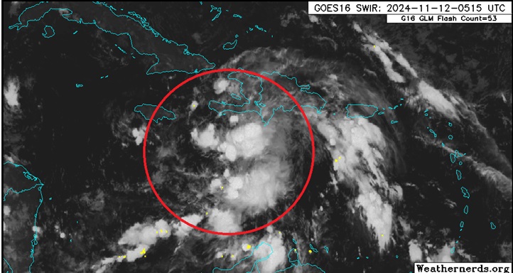
Development in the Caribbean is becoming likely this week from a tropical wave interacting with a broad area of low pressure in the region and models are exceptionally bullish on this Invest TBD's prospects for the time of year. Shear is forecast to be unseasonable low and SSTs unseasonably warm.
The next name on the list in the 2024 Atlantic Hurricane Season is Sara.
One might have to look back as far as 1985's Kate for a possible analog to current modeling and this system may take many by surprise if it does form and track towards the southeast US. Kate became the latest mainland US-landfalling hurricane on record.
We already have a Forecast Lounge up to go deeper into this system's modeling.
An Invest number will likely be assigned very soon and relevant links will be added.
Sara Event Related Links
Tropical Tidbits Page on system
[https://flhurricane.com/floatanimator.php?year=2024&storm=19 Flhurricane Satellite Floater Animation of Sara
GOES Floater
Tomer Berg Info page for Sara
Clark Evans Track Model Plot of Sara
(Animated!) Model Plots in Google Earth - In Google Maps
Clark Evans Intensity Model Plot of Sara (Animated!)
Clark Evans Track Plot of Sara
Clark Evans Top 10 Analog Storms for Sara
More model runs on from RAL/Jonathan Vigh's page
NRL Info on Sara -- RAMMB Info
COD Atlantic Satellite View
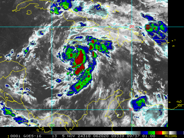
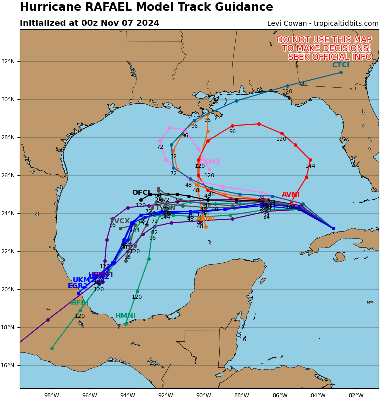
Rafael is winding down after having become the farthest west tracking Major Hurricane in the Atlantic basin in any November on record. Rafael's moisture is funneling into Louisiana this weekend, enhancing flooding rains across this region.
NHC:
Quote:
....Rainfall indirectly associated with the moisture from Rafael is expected to lead to 3 to 6 inches of rain, with local amounts to 10 inches, across portions of Southwest and Central Louisiana through Sunday morning. This rain will lead to potentially significant flash flooding....
4:00PM EST 4 November 2024 Update
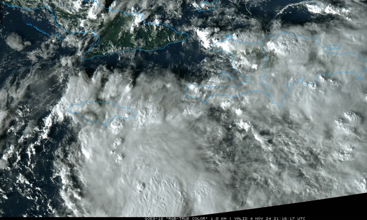
EIGHTEEN has strengthened into Tropical Storm Rafael. Rafael is forecast to become a hurricane in short order, and has the potential to undergo RI as it heads towards Cuba.
NWS National Hurricane Center Miami FL AL182024
400 PM EST Mon Nov 04 2024
...DEPRESSION STRENGTHENS INTO TROPICAL STORM RAFAEL...
...TROPICAL STORM CONDITIONS EXPECTED TO BEGIN IN JAMAICA LATE TONIGHT...
SUMMARY OF 400 PM EST...2100 UTC...INFORMATION
----------------------------------------------
LOCATION...15.5N 76.7W
ABOUT 175 MI...280 KM S OF KINGSTON JAMAICA
ABOUT 395 MI...635 KM SE OF GRAND CAYMAN
MAXIMUM SUSTAINED WINDS...45 MPH...75 KM/H
PRESENT MOVEMENT...N OR 10 DEGREES AT 9 MPH...15 KM/H
MINIMUM CENTRAL PRESSURE...997 MB...29.44 INCHES
WATCHES AND WARNINGS
--------------------
CHANGES WITH THIS ADVISORY:
A Tropical Storm Watch has been issued for the Lower and Middle Florida Keys from Key West to west of the Channel 5 Bridge, and for the Dry Tortugas.
SUMMARY OF WATCHES AND WARNINGS IN EFFECT:
A Hurricane Warning is in effect for...
* Cayman Islands
A Hurricane Watch is in effect for...
* Cuban provinces of Pinar del Rio, Artemisa, La Habana, Mayabeque, Matanzas, and the Isle of Youth
A Tropical Storm Warning is in effect for...
* Jamaica
A Tropical Storm Watch is in effect for...
* Cuban provinces of Villa Clara, Cienfuegos, Sancti Spiritus, Ciego de Avila, Camaguey, and Las Tunas
* Lower and Middle Florida Keys from Key West to west of the Channel 5 Bridge
* Dry Tortugas
10:00AM EST 4 November 2024 Update
Recon finds PTC 18 has become a Tropical Cyclone, therefore is now TD 18 and soon to become Rafael based on everything we see.
SUMMARY OF WATCHES AND WARNINGS IN EFFECT:
A Hurricane Warning is in effect for...
* Cayman Islands
A Hurricane Watch is in effect for...
* Cuban provinces of Pinar del Rio, Artemisa, La Habana, Mayabeque, Matanzas, and the Isle of Youth
A Tropical Storm Warning is in effect for...
* Jamaica
A Tropical Storm Watch is in effect for...
* Cuban provinces of Villa Clara, Cienfuegos, Sancti Spiritus, Ciego de Avila, Camaguey, and Las Tunas
1:00PM EST 3 November 2024 Update
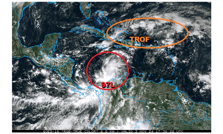
Above: Two Areas of Interest in the W ATL that have potential to become TCs within the next 48 hours.
Of greatest interest is Invest 97L, which early modeling suggests could become yet another hurricane in short order. Recon is investigating this incipient cyclone today, and the data collected will used by these models to greatly improve their forecast simulations going forward.
Original Update
Conditions favorable for a back-loaded 2024 Atlantic Hurricane Season continue, and we are now watching four areas of interest in the Atlantic, one of which has been named today (Patty), and another that has just been Invest tagged this morning (97L).
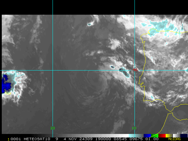
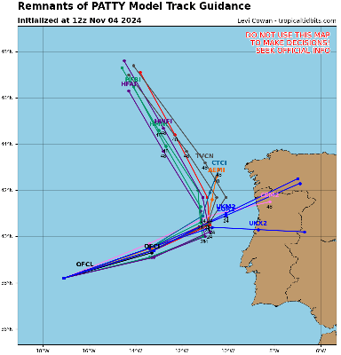
Patty has become the sixteenth named storm of the season. A Tropical Storm Warning is up for all of the Azores islands in the northern Atlantic.
Closer to home, Invest 97L is likely to become a named storm over the next few days and interests in and around the Caribbean may want to begin paying closer attention. While models suggest a track towards the southern US is very possible, there are a number of known unknowns, and it is too soon tell. We are already doing some deeper dives into its potential in the Rafael Forecast Lounge
Patty Event Related Links
Tropical Tidbits Page on system
[https://flhurricane.com/floatanimator.php?year=2024&storm=17 Flhurricane Satellite Floater Animation of Patty
GOES Floater
Tomer Berg Info page for Patty
Clark Evans Track Model Plot of Patty
(Animated!) Model Plots in Google Earth - In Google Maps
Clark Evans Intensity Model Plot of Patty (Animated!)
Clark Evans Track Plot of Patty
Clark Evans Top 10 Analog Storms for Patty
More model runs on from RAL/Jonathan Vigh's page
NRL Info on Patty -- RAMMB Info
COD Atlantic Satellite View
Rafael Event Related Links
Tropical Tidbits Page on system
[https://flhurricane.com/floatanimator.php?year=2024&storm=18 Flhurricane Satellite Floater Animation of Rafael
GOES Floater
Tomer Berg Info page for Rafael
Clark Evans Track Model Plot of Rafael
(Animated!) Model Plots in Google Earth - In Google Maps
Clark Evans Intensity Model Plot of Rafael (Animated!)
Clark Evans Track Plot of Rafael
Clark Evans Top 10 Analog Storms for Rafael
More model runs on from RAL/Jonathan Vigh's page
NRL Info on Rafael -- RAMMB Info
COD Atlantic Satellite View
Mid October After Milton: Nadine and Oscar
Posted: 04:02 AM 11 October 2024 | 2 Comments | Add Comment | Newest: 01:56 PM 20-Oct EDT
...HURRICANE WARNING ISSUED FOR TURKS AND CAICOS ISLANDS AND SOUTHEAST BAHAMAS...
Quote:
SUMMARY OF 200 PM EDT...1800 UTC...INFORMATION
----------------------------------------------
LOCATION...21.4N 70.6W
ABOUT 165 MI...260 KM ESE OF THE SOUTHEASTERN BAHAMAS
ABOUT 470 MI...755 KM E OF CAMAGUEY CUBA
MAXIMUM SUSTAINED WINDS...80 MPH...130 KM/H
PRESENT MOVEMENT...W OR 270 DEGREES AT 12 MPH...19 KM/H
MINIMUM CENTRAL PRESSURE...989 MB...29.21 INCHES
WATCHES AND WARNINGS
--------------------
CHANGES WITH THIS ADVISORY:
The government of the Bahamas has issued a Hurricane Warning for the Turks and Caicos Islands and the Southeastern Bahamas.
The government of Cuba has issued a Hurricane Watch for the provinces of Guantanamo, Holguin, and Las Tunas.
SUMMARY OF WATCHES AND WARNINGS IN EFFECT:
A Hurricane Warning is in effect for...
* Turks and Caicos Islands
* Southeastern Bahamas
A Hurricane Watch is in effect for...
* Cuban Provinces of Guantanamo, Holguin, and Las Tunas
A Tropical Storm Warning is in effect for...
* Cuban Provinces of Guantanamo, Holguin, and Las Tunas
A Tropical Storm Watch is in effect for...
* Cuba Provence of Camaguey
9:30AM EDT 19 October 2024 Update
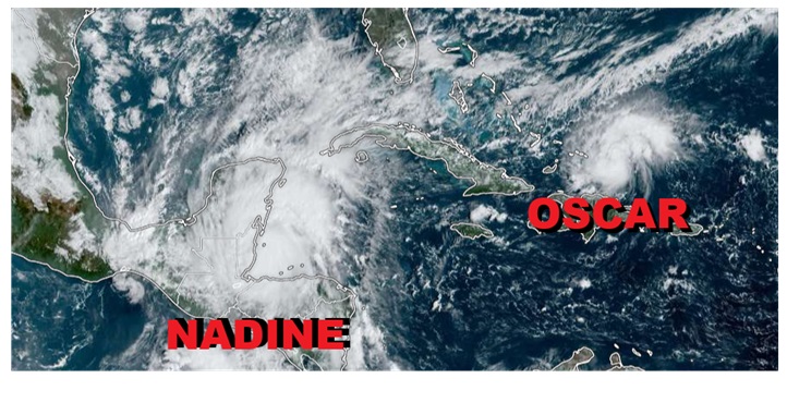
Potential Tropical Cyclone FIFTEEN is now Tropical Storm Nadine just offshore of Belize, and this morning, Invest 94L has become Tropical Storm Oscar, just east of the Turks and Caicos.
Ciel
9:30PM EDT 18 October 2024 Update
FIFTEEN is forecast to become Nadine prior to making landfall along or near Belize this weekend, and we do have a forecast lounge up on this system: Nadine Forecast Lounge
Ciel
4:30PM EDT 18 October 2024 Update
Invest 95L in the northwest Caribbean is now PTC FIFTEEN and NHC Advisories are being issued. Those with interests in Central America and the Yucatan may want to begin paying close attention as a potentially flood-producing tropical cyclone is likely this weekend.
Ciel
6:15PM EDT 13 October 2024 Update
Invest 94L in the eastern Tropical Atlantic could become a concern later this week for portions of the Antilles, and we have started a Forecast Lounge on it Oscar Forecast Lounge
Ciel
Original Update
The last advisories on Milton have been issued and beyond Milton, Leslie is still churning, and invest 94L is also potentially the next system in the eastern Atlantic that may make it all the way to the Caribbean. This year has a lot of late activity in the MDR, which is fairly unusual for October, since typically we start looking closer in toward the Gulf and Western Caribbean for development this time of year.
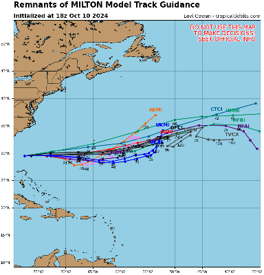
Milton had significant impacts to Florida from tornadoes, to rain to surge and wind, but the rapid shear induced weakening prevented the truly catastrophic scale.
Patty Event Related Links
Tropical Tidbits Page on system
[https://flhurricane.com/floatanimator.php?year=2024&storm=17 Flhurricane Satellite Floater Animation of Patty
GOES Floater
Tomer Berg Info page for Patty
Clark Evans Track Model Plot of Patty
(Animated!) Model Plots in Google Earth - In Google Maps
Clark Evans Intensity Model Plot of Patty (Animated!)
Clark Evans Track Plot of Patty
Clark Evans Top 10 Analog Storms for Patty
More model runs on from RAL/Jonathan Vigh's page
NRL Info on Patty -- RAMMB Info
COD Atlantic Satellite View
Invest 97L Event Related Links
Tropical Tidbits Page on system
[https://flhurricane.com/floatanimator.php?year=2024&storm=18 Flhurricane Satellite Floater Animation of 97L
GOES Floater
Tomer Berg Info page for 97L
Clark Evans Track Model Plot of 97L
(Animated!) Model Plots in Google Earth - In Google Maps
Clark Evans Intensity Model Plot of 97L (Animated!)
Clark Evans Top 10 Analog Storms for 97L
More model runs on from RAL/Jonathan Vigh's page
NRL Info on 97L -- RAMMB Info
COD Atlantic Satellite View
Tampa Area Media:
Southwest Florida (Naples/Ft.Myers) Area Media:
News Media (East Central Florida):
Television:
- WESH Channel 2 (NBC)
- WKMG Channel 6 (CBS)
- WFTV Channel 9 (ABC)
- Central Florida News 13 (BrightHouse Networks)
- WOFL Channel 35 (FOX)
Newspapers:
News Radio:
- 107.3 FM 580AM WDBO News/Talk Orlando - Recommended for East Central Florida
- 102.5 FM WFLA News/Talk Orlando
- 1150 WNDB Daytona
- WMMB (1240 AM) and WMMV (1350 AM) News/Talk Melbourne
Check local media and officials when a storm is approaching your area.
Milton Makes Landfall with Catastrophic Impacts
Posted: 10:07 AM 05 October 2024 | 8 Comments | Add Comment | Newest: 06:57 PM 07-Oct EDT
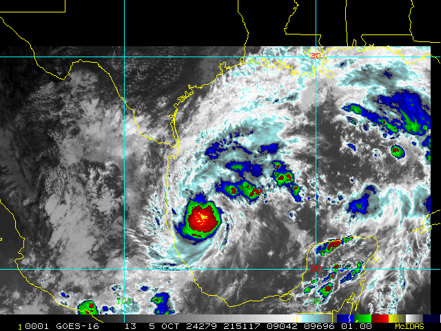
Landfall has occurred near Siesta Key, Fl. NHC:
Quote:
...EXTREMELY DANGEROUS CATEGORY 3 HURRICANE MILTON MAKES LANDFALL
NEAR SIESTA KEY FLORIDA....
...LIFE-THREATENING STORM SURGE, EXTREME WINDS, AND FLASH FLOODING
OCCURRING OVER THE CENTRAL FLORIDA PENINSULA...
NWS Doppler radar data indicate the eye of Hurricane Milton has made landfall near Siesta Key in Sarasota County along the west coast of Florida.
A sustained wind of 78 mph (126 km/h) and a gust of 97 mph (156 km/h) was recently reported at a NOAA C-MAN station in Venice. A sustained wind of 77 mph (124 km/h) and a gust of 100 mph (161 km/h) was recently reported at a WeatherFlow station at Egmont Channel. A sustained wind of 67 mph (107 km/h) and a gust of 83 mph (133 km/h) was recently reported at a WeatherFlow station at Skyway Fishing Pier. A sustained wind of 40 mph (64 km/h) and a gust of 73 mph (117 km/h) was recently reported at the Sarasota-Bradenton International Airport.
The next update will be at 900 PM EDT (0100 UTC).
SUMMARY OF 830 PM EDT...0030 UTC...INFORMATION
-----------------------------------------------
LOCATION...27.3N 82.6W
ABOUT 5 MI...10 KM W OF SARASOTA FLORIDA
ABOUT 115 MI...185 KM SW OF ORLANDO FLORIDA
MAXIMUM SUSTAINED WINDS...120 MPH...205 KM/H
PRESENT MOVEMENT...ENE OR 60 DEGREES AT 15 MPH...24 KM/H
MINIMUM CENTRAL PRESSURE...954 MB...28.17 INCHES
1:30PM EDT 9 October 2024 Update
Time has mostly run out to safely prepare for life-threatening weather that is already spreading inland across the state, and now is the time to hunker down, away from the water ("Run from the water!"), and protected from the wind and debris ("Hide from the wind!")
Quote:
Hurricane Milton Tropical Cyclone Update
NWS National Hurricane Center Miami FL AL142024
100 PM EDT Wed Oct 09 2024
...TROPICAL-STORM-FORCE WINDS JUST OFFSHORE THE WEST COAST OF FLORIDA...
...100 PM EDT POSITION UPDATE...
Milton is currently moving north-northeastward or 030/15 kt. A turn towards the northeast is anticipated with a slower forward speed later this evening.
Tropical-storm-force winds are just offshore and now is the time to stay inside and away from windows. Listen for updates and be ready in case you lose electrical power. Keep a battery-powered radio, charged cell phone and flashlight handy.
Ciel
4:55PM EDT 8 October 2024 Update
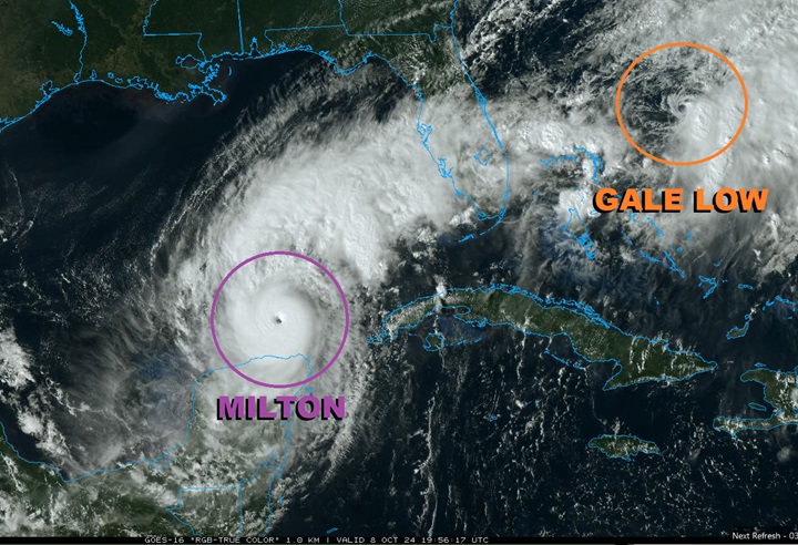
Hurricane Milton is Category 5 once again. Earlier today the cyclone completed an eyewall replacement and has been reorganizing at a dizzying pace. There is a slight shift to the south with the 18z models, and indeed how it has been tracking overall, and the official NHC cone is nudged a touch in that direction. Everyone is reminded that the hurricane is not itself a point or a line.
To Milton's northeast, an area of frontal boundary and lower pressure that in many ways had possibly been adding some extra tug to the north, is in the process of consolidating off the east coast of Florida and is now a stout gale low that may be acquiring some subtropical and tropical characteristics
Ciel
5:00PM EDT 7 October 2024 Update
HURRICANE AND STORM SURGE WARNINGS ISSUED FOR PORTIONS OF THE FLORIDA WEST COAST
SUMMARY OF 400 PM CDT...2100 UTC...INFORMATION
----------------------------------------------
LOCATION...21.8N 90.8W
ABOUT 80 MI...125 KM WNW OF PROGRESO MEXICO
ABOUT 675 MI...1085 KM SW OF TAMPA FLORIDA
MAXIMUM SUSTAINED WINDS...180 MPH...285 KM/H
PRESENT MOVEMENT...E OR 90 DEGREES AT 10 MPH...17 KM/H
MINIMUM CENTRAL PRESSURE...905 MB...26.73 INCHES
WATCHES AND WARNINGS
--------------------
CHANGES WITH THIS ADVISORY:
A Storm Surge Warning has been issued for the west coast of Florida from Flamingo northward to the Suwannee River, including Charlotte Harbor and Tampa Bay.
A Hurricane Warning has been issued for the west coast of Florida from Bonita Beach northward to the mouth of the Suwannee River, including Tampa Bay.
A Tropical Storm Warning has been issued for the west coast of Florida south of Bonita Beach to Flamingo, including Lake Okeechobee, and north of the mouth of the Suwannee River northward and westward to Indian Pass. A Tropical Storm Warning has also been issued for all of the Florida Keys, including the Dry Tortugas and Florida Bay.
A Storm Surge Watch has been issued for the U.S. east coast from Sebastian Inlet Florida to Edisto Beach South Carolina, including the St. Johns River.
A Hurricane Watch has been issued along the east coast of the Florida Peninsula from the St. Lucie/Indian River County Line northward to the mouth of the St. Marys River.
A Tropical Storm Watch has been issued along the east coast of the Florida Peninsula south of the St. Lucie/Indian River County Line southward to Flamingo. A Tropical Storm Watch has also been issued along the coast of Georgia and South Carolina from north of the mouth of the St. Marys River to South Santee River, South Carolina.
SUMMARY OF WATCHES AND WARNINGS IN EFFECT:
A Storm Surge Warning is in effect for...
* West coast of Florida from Flamingo northward to the Suwannee
River, including Charlotte Harbor and Tampa Bay
A Hurricane Warning is in effect for...
* Celestun to Rio Lagartos
* Florida west coast from Bonita Beach northward to the mouth of the
Suwannee River, including Tampa Bay
A Storm Surge Watch is in effect for...
* Sebastian Inlet to Edisto Beach, including St. Johns River
A Hurricane Watch is in effect for...
* Rio Lagartos to Cabo Catoche
* Campeche to south of Celestun
* Dry Tortugas
* Lake Okeechobee
* Florida west coast from Chokoloskee to south of Bonita Beach
* Florida east coast from the St. Lucie/Indian River County Line
northward to the mouth of the St. Marys River
A Tropical Storm Warning is in effect for...
* Rio Lagartos to Cancun
* Campeche to south of Celestun
* All of the Florida Keys, including Dry Tortugas
* Lake Okeechobee
* Florida west coast from Flamingo to south of Bonita Beach
* Florida west coast from north of the mouth of the Suwanee River to
Indian Pass
A Tropical Storm Watch is in effect for…
* East coast of the Florida Peninsula south of the St. Lucie/Indian
River County Line southward to Flamingo
* Coast of Georgia and South Carolina from north of the mouth of the
St. Marys River to South Santee River, South Carolina
11:55AM EDT 7 October 2024 Update
Milton is now Cat 5 on the Saffir-Simpson Wind Scale.
Ciel
9:15AM EDT 7 October 2024 Update
Milton continues to RI and recon has just found that the Major Hurricane is up to 150 MPH, still strengthening. There continues to be indications that an eyewall replacement cycle could occur today, and this would result in a process that makes Milton larger and an even greater storm surge producer on Florida.
Preps to protect life and property should be rushing to completion today.
Ciel
4:45PM EDT 6 October 2024 Update
A Hurricane Watch has been issued for the northern coast of the Yucatan Peninsula and Watches and Warnings will likely be issued for portions of Florida within the next 6-12 or so hours.
Milton is now forecast by NHC to peak at 145 MPH (mid-range Cat 4 on the Saffir-Simpson Wind Scale), but as noted in their discussion, this could be conservative, and Cat 5 is solidly on the table. In fact, some of our better hurricane models are now in the high-end Cat 5 range (what many might call "Cat 6").
Putting the wind threat aside for a moment, which is very high, it is forecast that Milton begins its extra-tropical transition phase prior to landfall, or at the very latest, prior to entering the east coast of Florida. This transitional period is expected to result in lowering the hurricane's top-line max wind speeds, but come at a cost to all of a wind field that spreads out, producing damage over an even greater area, as well as producing surge much further up and down the coasts than if the core held tightly.
Also, the threat of inland flooding will be substantial. The PRE event that has set up in advance of Milton's approach is already producing flooding, and this will be exacerbated during the landfall and passage of Milton.
Those living in or with interests in Florida from the Big Bend region all the way to the South Florida Keys are encouraged to begin taking preparations to protect life and property.
Ciel
1:45PM EDT 6 October 2024 Update
Recon has confirmed that Milton is now a hurricane and NHC is updating the new Advisory at this time.
Ciel
8:00AM EDT 6 October 2024 Update
NOAA Recon aircraft finds Milton stronger with 991mb pressure and 60mph winds. Forecast track remains mostly unchanged, models should tighten up a bit better later today (not until after the 12z runs) with recon data added in. Those in the Florida peninsula in the cone should make preparations today and tomorrow. Hurricane watches for some areas of Florida may be issued sometime tonight or tomorrow.
12:25PM CDT Update
TD 14 has become Tropical Storm Milton.
10:15AM Update
Advisories for TD#14 to begin at 11AM EDT.
Original Update
The area in the southwestern Gulf of Mexico is now up to a 90% chance to develop, and those along the west coast of Florida should watch it closely as the potential is developing for it to possibly a bad one for somewhere along the southwest or Western Central Florida coastline, and also impact the peninsula to the Atlantic. Including Tampa.
Models range from Naples to near Crystal River, with the angle coming from the west not as oblique as the ones from the West Caribbean, there may be a little more accuracy in track once advisories start to be issued, which could start later tonight or tomorrow depending on how much the system develops.
Timing is most likely for a Wednesday landfall with impacts being felt a day or two (or even Sunday) before in the form of very heavy rain, and more impacts toward later Tuesday surge and wind, with landfall likely daytime Wednesday (which could change)
The worst surge impacts at landfall will likely be at and just to the right (south) of the landfall point, on exit into the Atlantic that switches to the left (north) side with onshore winds.
MILTON FORECAST LOUNGE
Milton Event Related Links
Tropical Tidbits Page on system
[https://flhurricane.com/floatanimator.php?year=2024&storm=14 Flhurricane Satellite Floater Animation of Milton
GOES Floater
Tomer Berg Info page for Milton
Clark Evans Track Model Plot of Milton
(Animated!) Model Plots in Google Earth - In Google Maps
Clark Evans Intensity Model Plot of Milton (Animated!)
Clark Evans Track Plot of Milton
Clark Evans Top 10 Analog Storms for Milton
More model runs on from RAL/Jonathan Vigh's page
NRL Info on Milton -- RAMMB Info
COD Atlantic Satellite View
Kirk Event Related Links
Tropical Tidbits Page on system
[https://flhurricane.com/floatanimator.php?year=2024&storm=12 Flhurricane Satellite Floater Animation of Kirk
GOES Floater
Tomer Berg Info page for Kirk
Clark Evans Track Model Plot of Kirk
(Animated!) Model Plots in Google Earth - In Google Maps
Clark Evans Intensity Model Plot of Kirk (Animated!)
Clark Evans Track Plot of Kirk
Clark Evans Top 10 Analog Storms for Kirk
More model runs on from RAL/Jonathan Vigh's page
NRL Info on Kirk -- RAMMB Info
COD Atlantic Satellite View
Leslie Event Related Links
Tropical Tidbits Page on system
[https://flhurricane.com/floatanimator.php?year=2024&storm=13 Flhurricane Satellite Floater Animation of Leslie
GOES Floater
Tomer Berg Info page for Leslie
Clark Evans Track Model Plot of Leslie
(Animated!) Model Plots in Google Earth - In Google Maps
Clark Evans Intensity Model Plot of Leslie (Animated!)
Clark Evans Track Plot of Leslie
Clark Evans Top 10 Analog Storms for Leslie
More model runs on from RAL/Jonathan Vigh's page
NRL Info on Leslie -- RAMMB Info
COD Atlantic Satellite View
Tampa Area Media:
Southwest Florida (Naples/Ft.Myers) Area Media:
News Media (East Central Florida):
Television:
- WESH Channel 2 (NBC)
- WKMG Channel 6 (CBS)
- WFTV Channel 9 (ABC)
- Central Florida News 13 (BrightHouse Networks)
- WOFL Channel 35 (FOX)
Newspapers:
News Radio:
- 107.3 FM 580AM WDBO News/Talk Orlando - Recommended for East Central Florida
- 102.5 FM WFLA News/Talk Orlando
- 1150 WNDB Daytona
- WMMB (1240 AM) and WMMV (1350 AM) News/Talk Melbourne
Check local media and officials when a storm is approaching your area.
Active Phase of Atlantic Continues into October
Posted: 03:29 PM 01 October 2024 | 1 Comment | Add Comment | Newest: 09:34 AM 03-Oct EDT
Recovery operations continue from Major Hurricane Helene, which is now the deadliest CONUS-landfalling tropical cyclone since Katrina. The tragic loss of life from Helene is mostly due to the all-too-often underappreciated inland flooding, and maybe finally a move to a more comprehensive TC Impacts Scale rather than merely a wind scale (Saffir Simpson) will start.
Unfortunately, this season is not yet over, with climatologically about a quarter of the activity remaining, and there is a risk that this year could even continue to be back-loaded if not also go into overtime, and we are now watching two named TCs (record-setting Major Hurricane Kirk, and Leslie, which is likely to become a strong hurricane as well), plus three additional Areas of Interest.
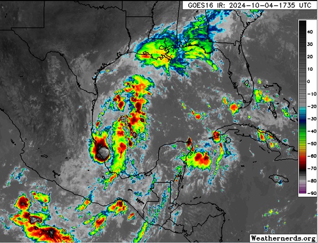
Closest to home is the feature we have been watching that is now in the western Gulf of Mexico and has increasing model support for significant development. While this system does not yet have an Invest tag, one could be assigned later today or sometime this weekend, and interests from eastern Mexico to the northern Gulf coast states and Florida may want to begin paying closer attention.
We do have a Forecast Lounge up on the Gulf Area of Interest: 92L Lounge
Original Update
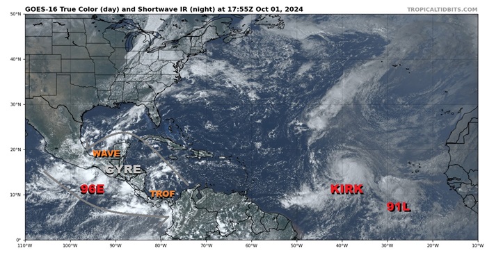
After being in hibernation during the climo peak of the season, the Atlantic basin turned on a dime last month with the arrival of a very favorable MJO pulse, and the generally supportive to very supportive conditions for TC development persist as we start the month of October.
Most recently and closest to home, a gyre is apparent over Central America, helping lift up and enhance a wave that has just tracked into the Bay of Campeche on the Atlantic side of the Isthmus of Tehuantepec, a preexisting trof that has come off northwestern South America, and also an area of low pressure (Invest 96E) on the Pacific side of the Isthmus of Tehuantepec. All three of these disturbances are likely to influence development, if any, in the Western Atlantic (Gulf and Caribbean) over the next few days. There is also some potential for 96E to cross over into the Gulf.
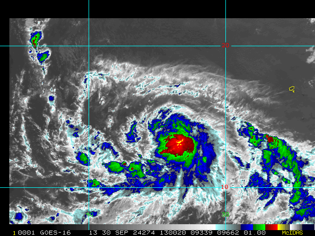
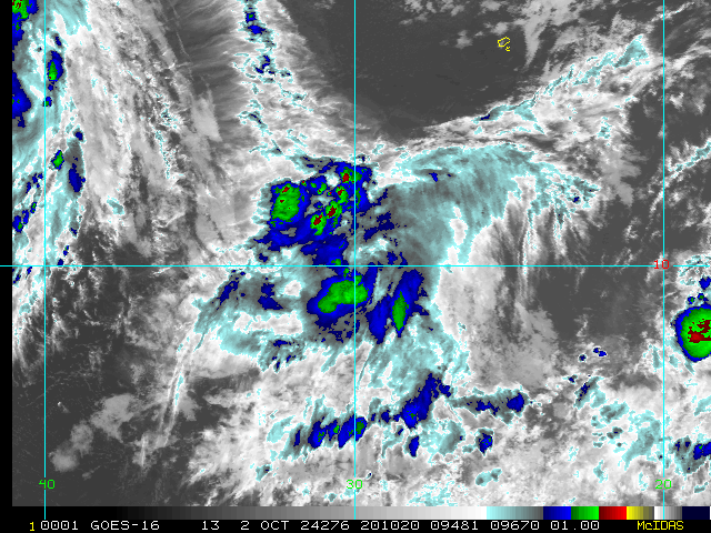
Way out in the eastern Tropical Atlantic, recently-named Kirk is now a hurricane and forecast to become an ACE building Major far away from North America, and also a stout low behind Kirk, Invest 91L, is likely to become a TC any day now. 91L's future track is less certain and will be watched.
Kirk Event Related Links
Tropical Tidbits Page on system
[https://flhurricane.com/floatanimator.php?year=2024&storm=12 Flhurricane Satellite Floater Animation of Kirk
GOES Floater
Tomer Berg Info page for Kirk
Clark Evans Track Model Plot of Kirk
(Animated!) Model Plots in Google Earth - In Google Maps
Clark Evans Intensity Model Plot of Kirk (Animated!)
Clark Evans Track Plot of Kirk
Clark Evans Top 10 Analog Storms for Kirk
More model runs on from RAL/Jonathan Vigh's page
NRL Info on Kirk -- RAMMB Info
COD Atlantic Satellite View
Leslie Event Related Links
Tropical Tidbits Page on system
[https://flhurricane.com/floatanimator.php?year=2024&storm=13 Flhurricane Satellite Floater Animation of Leslie
GOES Floater
Tomer Berg Info page for Leslie
Clark Evans Track Model Plot of Leslie
(Animated!) Model Plots in Google Earth - In Google Maps
Clark Evans Intensity Model Plot of Leslie (Animated!)
Clark Evans Track Plot of Leslie
Clark Evans Top 10 Analog Storms for Leslie
More model runs on from RAL/Jonathan Vigh's page
NRL Info on Leslie -- RAMMB Info
COD Atlantic Satellite View
Invest 92L Event Related Links
Tropical Tidbits Page on system
[https://flhurricane.com/floatanimator.php?year=2024&storm=14 Flhurricane Satellite Floater Animation of 92L
GOES Floater
Tomer Berg Info page for 92L
Clark Evans Track Model Plot of 92L
(Animated!) Model Plots in Google Earth - In Google Maps
Clark Evans Intensity Model Plot of 92L (Animated!)
Clark Evans Top 10 Analog Storms for 92L
More model runs on from RAL/Jonathan Vigh's page
NRL Info on 92L -- RAMMB Info
COD Atlantic Satellite View

